Corporate computer-aided system of mining planning, control and maintenance
Purpose
Automation of the entire spectrum of graphic and report works of experts of design, surveying and geological departments of a mining enterprise with mineral product stratal occurrence.
Features
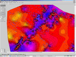
The system is intended for automation of work of professionals of geological survey department and mining operations planning department. On the basis of digital plans being finite element model preparation is carried out and geodynamic and hydrodynamic modeling is implemented. Computing performance increase is realized by using CUDA technology. Provides network access to map information based on ORACLE / SPATIAL technology.
Automation of the entire spectrum of graphic and report works of experts of design, surveying and geological departments of a mining enterprise with mineral product stratal occurrence.
Features
The system is intended for automation of work of professionals of geological survey department and mining operations planning department. On the basis of digital plans being finite element model preparation is carried out and geodynamic and hydrodynamic modeling is implemented. Computing performance increase is realized by using CUDA technology. Provides network access to map information based on ORACLE / SPATIAL technology.
- Creations and daily operation with digital multi-layer maps of the mines and regions of a Earth surface within the limits of the claims and special software for construction of hard copies of computer maps;
- constructions, analysis and visualization of maps of modifications of various geologic and hydro-geological characteristics of rock strata;
- designing and scheduling of mining operations;
- geology and surveying accompany of mining operations;
- creations and daily operation with the document "Emergency control plans" and its uses in extreme situations;
- modeling, calculation and forecasting of the basic characteristics of a Earth surface Subsidence processes in areas of underground mining operations; the prognosis and maps of modifications of a Earth surface relief in view of surface Subsidence;
- modeling of a condition and calculation of service life of underground cavities, buildings;
- modeling of various geomechanical processes in rock massif with underground buildings, cavities and infringements.

